By John Allen
Them was the days. I used to survey for a CRW ride route with a bicycle computer and a pushbutton-operated voice recorder. I took notes, calling out the mileage in each one. I’d prepare a cue sheet or draw a stick map from my notes. (Newcomers: stick maps showed all the turns, but each segment was bent so the route went more or less straight across the page.)
Technology advances. Now, with the RidewithGPS app on my smartphone, I can record a ride and convert it into a route. I also can lay out the route on a computer.
But by default, RidewithGPS gives only bare-bones turn-by-turn cues. Riders need to know what lane to merge into, well before reaching any complicated intersection. And RidewithGPS usually does not give any cue at all when a route goes straight through an intersection.
For that reason, I create custom cues. Here’s an example from the short version of the East European Ride, which I have led, You can find that ride in the CRW route library:
East European Ride, short, Spellman start, extended cues - A bike ride in Weston, MA (ridewithgps.com)
Between miles 15 and 16 in Concord, this ride turns left from Old Marlboro Road to Old Road to Nine Acre Corner, which has three northbound lanes: a left-turn-only lane, a through lane and a right-turn-only lane. The route then almost immediately crosses Route 2. My cues are these:
- · Prepare to turn left
- · Turn left into through lane on Old Rd to Nine Acre Corner
- · Cross MA-2
The image below is from an edit screen in RidewithGPS, which shows the cued locations. These are the three light green cartoon dialog balloons in the image, going from left to top right..
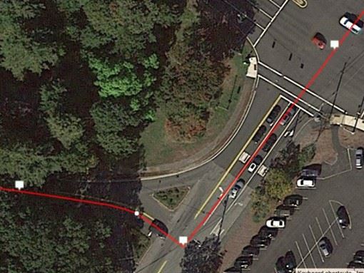
RidewithGPS places cues at turns by default, but when giving turn-by-turn navigation, Ride with GPS reads out each cue some distance ahead of the location shown on the map. So, for example, the cue in the image to turn left is read out before the left turn. This advance distance is adjustable in settings: you could increase it for a faster ride. But also for the safety of riders, you will want to place custom cues earlier when it is necessary to prepare with a lane change, or downhill. (In the dark ages before GPS, we painted arrows on the road earlier on downhills? Same idea.)
Notice also that the red line shown for the route takes a square corner for the left turn, and shows incorrect lane use. The Google data that RidewithGPS uses has one line of travel for both directions on a two-way roadway, and that can’t be right! But riders follow the cues, not the map, and the map displays too small anyway on a smartphone or GPS device to reveal its anomalies. Once again, the cues are what matters.
Sometimes cues are just wrong, even on a route created directly in RidewithGPS. A prime example is also on the East European Ride, just short of mile 24 in Weston, where Conant Road jogs slightly left as it crosses Route 117. RidewithGPS cues will tell you to turn left onto Route 117, then almost immediately turn right onto Conant Road. Why? It’s the square corners again. The lines for Conant Road north and south of Route 117 are slightly offset from one another. The result is not only confusing, it is a safety concern when riders are told suddenly and unexpectedly to change direction. In such situations, I delete one of the cues and customize the other. Here, I changed it to:
- Cross MA 117 and continue on Conant Road.
When riding to create a route, following it accurately will reduce the need to edit it later. Reviewing ride recordings from people who have followed a route can also help refine it for the next time it goes onto the CRW calendar. And when creating a route on the computer, the Draw Lines option may be needed to connect the route where the Google mapping car did not go. Mostly, these will be paths and entrances to rest stops. The need to use Draw Lines can mostly be avoided by starting with a recording of a ride. In either case, custom cues will be needed for the line segments: RidewithGPS creates cues automatically only where it can identify a road or path.
RidewithGPS editing software also lets you create Point of Interest icons. These include one for Caution. Points of interest display on the RidewithGPS map of a ride but do not create cues. A custom cue is needed to call out a hazard to the rider, for example: “loose gravel.” A custom cue can inform riders of anything – the split on a ride, length of a climb, distance to a rest stop, you name it.
I’m not CRW’s RidewithGPS guru, so I won’t go into detail about how to do the editing. But my instructions can set you on the right track.
No matter how you create a route, there’s no substitute for riding it shortly before the calendar date to check on details -- construction or other changes; the accuracy of cues in RidewithGPS – and as I have suggested in this article, to customize the cues in the interest of accuracy and safety.